
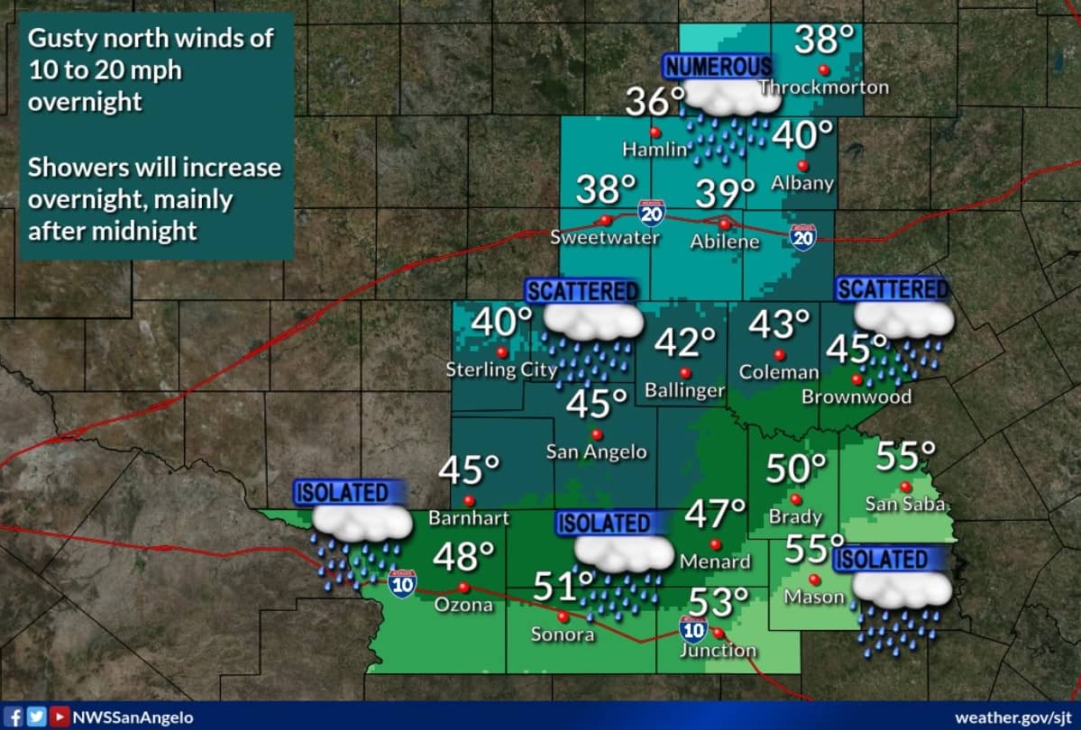
After a warm and pleasant Sunday, a very strong cold front will arrive Sunday night and send the KOXE listening area into a cold and wet weather pattern Monday through Wednesday. (Photo courtesy San Angelo National Weather Service and shows projected temperatures Monday morning)
Expect a wide variety of weather between Sunday night and Wednesday to include rain, which will be heavy at times, and temperatures near freezing by Tuesday morning. Colder temperatures are expected and could support wintry mix in places like Abilene, Sweetwater, Snyder and San Angelo areas. As of Sunday morning, forecast models were suggesting a less likely wintry mix in Brownwood/Early but this will need to be monitored closely. Forecast models are suggesting total rain amounts between Monday and Wednesday will range between 1 and 2 inches of rain is possible during the next three days.
Daytime Sunday – Sunshine and warm, temperatures are forecast to reach the upper 80’s before a late day front arrives.
Sunday Night – Cold Front Arrival Time – Between 7:00 pm and 10:00 pm Sunday evening
Temperature by 7:00 am Monday – Near 40-43 degrees. North wind 15-25 mph will put wind chills in the 30’s by the day you go to work and school Monday morning.
Monday – Rain is forecast to begin early morning and continue off and on all day. Projected rain totals during the day Monday are less than a half inch. Temperature during the day Monday will range from 36-40 degrees over the KOXE listening area. With north wind of 10-20 mph Monday, wind chills in the upper 20’s to low 30’s can be expected during the day.
Monday Night – Low Temperature Overnight Monday Night – 31-34 – Light freeze possible especially in Callahan, Coleman, Concho and counties west of there.
There will likely be a second wave of rain and thunderstorms coming in Monday night into Tuesday morning. Rain may be heavy at times. Doubtful road conditions will be icy in our area but you will need to monitor the latest weather information as we are on the borderline of the freeze mark.
Tuesday – High Temperature on Tuesday – 33-37 degrees – Rain and storms likely off and on during the day. With north wind 10 to 20, wind chills in the upper 20’s should be expected.
Tuesday Night – This may be the time when we receive the most rain and thunderstorms as an upper level low moves over the area. Low Temperature Tuesday Night – Near steady 34-37 degrees. Rain heavy at times, could mix with sleet but, with temperatures forecast above freezing, road conditions are not forecast to be icy at this time.
High Temperature on Wednesday – Mid 40’s with only a slight chance for light rain.
Thursday – Sunshine returns with temperatures 55-60.
Monitor the latest weather conditions before traveling across West Central Texas Monday through Wednesday. Watch for a KOXE video weather update at 7:15 am Monday on KOXE.com.
(by KOXE Meteorologist Randy Turner)