
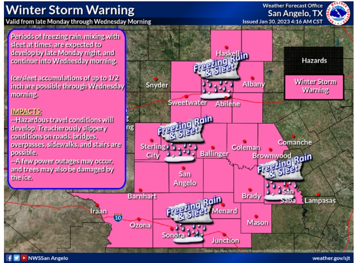
The National Weather Service has issued a Winter Storm Warning for Brown and all surrounding counties in the KOXE listening area from Noon today (Monday) through 9:00 am Wednesday. An ice storm is forecast to materialize starting slowly today with light precipitation and worsening tonight, Tuesday and Tuesday night into Wednesday morning. The official statement from the National Weather Service is below.
* WHAT… For the Winter Storm Warning, several rounds of mixed wintry precipitation are expected, mainly in the form of freezing rain and/or sleet, with the heavier precipitation expected to begin late Monday night. Total ice accumulations of one tenth to one half of an inch will be possible from late
Monday night through Wednesday morning. For the Winter Weather Advisory this morning, light freezing rain, possibly mixing with sleet is expected. Total ice accumulations of a light glaze.
* WHERE…West central Texas.
* WHEN…For the Winter Storm Warning, from noon today to 9 AM CST Wednesday. For the Winter Weather Advisory, until noon CST
today.
* IMPACTS…Accumulation of ice on roadway, especially bridges and overpasses will cause hazardous travel conditions from late Monday night through Tuesday night. A few power outages and damage to trees will also be possible due to the ice accumulations.
PRECAUTIONARY/PREPAREDNESS ACTIONS…
If you must travel, keep an extra flashlight, food, and water in your vehicle in case of an emergency.
Slow down and use caution while traveling. Prepare for possible power outages.
The latest road conditions for the state you are calling from can be obtained by calling 5 1 1.
